There are numerous sea stacks along the Oregon coast. This big one is "Haystack Rock," 235-feet high. The sea stacks used to be part of the shoreline, which has since moved inland.

They provide safe nesting sites for a variety of seabirds, but all I saw at this time of the year were seagulls.

There are also many lighthouses along the Oregon coast. Tillamook Rock Lighthouse, called "Terrible Tilly," is located on a sea stack more than a mile off shore. In 1880, it was a harrowing construction project, and a demanding post for the lighthouse keepers.

Cape Meares Lighthouse is the shortest on the Oregon coast. Unfortunately, it was badly damaged by vandals this past January. The lens is broken and is irreplacable.

Near Cape Mears is the Octopus Tree. It is thought that Native Americans trained the tree into this shape in order to use it in funerals. The dead were put into canoes, and then rested in the trees. The tree is 250-300 years old, 46 feet in circumference, and over 100 feet tall.

Also nearby is this Sitka Spruce, the largest one of it's kind in Oregon. It is 750-800 years old, 48 feet in circumference, and 144 feet tall.

I went to Pacific City to see the flat-bottomed fishing boats called "dories" land on the beach, but unfortunately, none showed up. Instead, I watched people climb a gigantic sand dune.

While in the area, we stayed at the Tillamook Air Park. During World War II, the navy stationed 8 large blimps here. The Blimps were used for anti-submarine coast patrol and convoy escort. It's now a huge museum.

Only cute little tourist airplanes use the airport now.

Tillamook has a great Saturday market. The fresh fruits and vegetables were actually quite reasonable, as were the doggie rules.

But here's what Tillamook is most noted for - CHEESE!

The factory is a very popular stop, primarily because there is FREE CHEESE!
 There are numerous sea stacks along the Oregon coast. This big one is "Haystack Rock," 235-feet high. The sea stacks used to be part of the shoreline, which has since moved inland.
 They provide safe nesting sites for a variety of seabirds, but all I saw at this time of the year were seagulls.
 There are also many lighthouses along the Oregon coast. Tillamook Rock Lighthouse, called "Terrible Tilly," is located on a sea stack more than a mile off shore. In 1880, it was a harrowing construction project, and a demanding post for the lighthouse keepers.
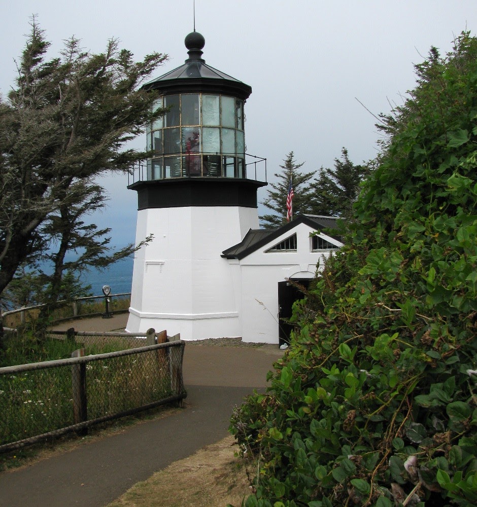 Cape Meares Lighthouse is the shortest on the Oregon coast. Unfortunately, it was badly damaged by vandals this past January. The lens is broken and is irreplacable.
 Near Cape Mears is the Octopus Tree. It is thought that Native Americans trained the tree into this shape in order to use it in funerals. The dead were put into canoes, and then rested in the trees. The tree is 250-300 years old, 46 feet in circumference, and over 100 feet tall.
 Also nearby is this Sitka Spruce, the largest one of it's kind in Oregon. It is 750-800 years old, 48 feet in circumference, and 144 feet tall.
 I went to Pacific City to see the flat-bottomed fishing boats called "dories" land on the beach, but unfortunately, none showed up. Instead, I watched people climb a gigantic sand dune.
 While in the area, we stayed at the Tillamook Air Park. During World War II, the navy stationed 8 large blimps here. The Blimps were used for anti-submarine coast patrol and convoy escort. It's now a huge museum.
 Only cute little tourist airplanes use the airport now.
 Tillamook has a great Saturday market. The fresh fruits and vegetables were actually quite reasonable, as were the doggie rules.
 But here's what Tillamook is most noted for - CHEESE!
 The factory is a very popular stop, primarily because there is FREE CHEESE!