Sunday, August 30, 2015
Down East in Maine
After Bangor, Phil and I headed "Down East" to the farthest Eastern section of Maine. We stayed at a beautiful spot near the "Reversing Falls."
This is an area of huge tide flows - 20+ feet between high and low tide. Here's high tide -
And here's low tide!
The area has some great wildlife. I saw this bald eagle across the water.
And we saw some seals, but they disappear fast and I got a lot of pictures like this.
This dragonfly attached himself to Phil and wouldn't let go.
But why is it called "Reversing Falls?" Here the tide is going out -
And here it is coming back in. Maybe it should be called Reversing Rapids, but it is still pretty impressive.
Here's another picture of high tide -
Versus low tide.
We drove further east to the candy-striped West Quoddy Head Light, built in 1858, replacing the original one built at the order of Thomas Jefferson in 1808.
While there, I got to be the easternmost person in the US, according to the sign there. However, I wonder about those Aleutian Islands on the other side of the 180 degree longitude...
Driving back to Lubec, we got a look at the Lubec Channel Light.
We had to go down some side roads to get a glimpse of it, and found some interesting things along the way.
We also wanted to get a look at the largest whirlpool in the western hemisphere. Named "Old Sow," it was really hard to see without being on a boat.
We also visited Eastport, where we saw a big fisherman.
But Phil liked this one better.
And Phil got his lobster.
Thursday, August 27, 2015
My 50th State!
Believe it or not, in all my travels, I had only been to 47 states. With Vermont and New Hampshire recently under my belt, the only state left was Maine. Our first stop was Bangor, and there are several attractions right in town.
We were welcomed by Paul Bunyan himself. Though not the first Paul Bunyan I've met, this is certainly the largest, at 31-feet tall. Even though Paul's wife, Lucette, has tried to make him eat healthier, Paul still weighs in at 3700 lbs.
Remember the Maine! This is the shield and scrolls recovered from the wreckage of the USS Maine, blown up in the Havana, Cuba harbor in 1898.
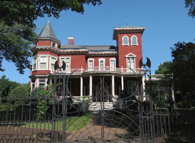
And Stephen King lives here! I love his unique fence, with the spider webs and bats.
We went on the short hike on the Orono Bog Boardwalk. It was pretty cool walking on top of 20 feet of peat moss.
But the neatest thing we saw was this Tomato Caterpillar, complete with lots of eggs.
We were there during the Bangor State Fair.
And of course we saw some cute little animals.
In the nearby town of Prospect is the Penobscot Narrows Bridge and Observatory, the tallest bridge observatory in the world at 420 feet.
Unfortunately, by the time we got to the top it was pretty foggy.
But out on the point, I could see Fort Knox. I can never pass up a fort, so that was our next stop.
The fort is made of granite and was built between 1844 and 1864.
It was used during the Civil War and the Spanish-American War.
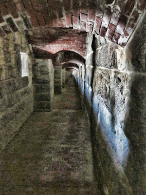
You can wander all around on your own, poking into all the nooks and crannies.
Fortunately, we brought a flashlight, because it's necessary in some places.
Oh, excuse me - I didn't know this room was occupied!
By now the fog had cleared, and we could see back to the bridge.
We stayed in Bangor right next to the airport, and one morning there were some strange planes taking off. First 5 Israeli jet fighters -
Then 5 Jordanian jet fighters -
And then 5 more Israeli jet fighters. Hmmmmm..... Maybe I should turn on the news. But I Googled it instead and found out the scoop.
The planes stopped here to refuel on their way to Red Flag 15-4 at Nellis Air Force Base in Nevada. Red Flag is a get-together where pilots from the US and NATO and other allied countries practice in realistic aerial war games! Who knew!
Tuesday, August 25, 2015
Walking in the Clouds
On the way to our next stop, Phil and I stopped over in Gorham, NH so that we could go up to the top of Mt. Washington, the highest point in the Northeast US. The road to the top starts out pretty tame, through some woods.
But it soon gets a lot steeper and scarier. The road goes up 4725 feet in 8 miles.
Whoa! I'm glad he's driving in the middle of the road. That's a pretty big dropoff over there.
We made it to the top, but we're in the clouds now.
Notice the building is chained down. The highest wind ever recorded happened right here - 231 mph!
This is what it looks like in the winter.
I made it to the top! 6,288 feet!
And right now I'm taller than anyone in the Northeast.
The clouds cleared up a little so we could see the cog railway engine and car show up.
The front is crooked so it is level going uphill.
The cog apparatus.
There's quite a lot to see at the top, some of which I almost missed because of the clouds. Then we started down the steep road. At least I wasn't on the dropoff side now. Believe it or not, this road first opened to the public in 1861.
We stopped on the way down to look at these rock piles. Not sure what the story is.
And we stopped at the Appalachian Trail so I could say I hiked it. (Yeah, right...)
In the evening, we drove north out of town on a road that you were supposed to see moose on. I loved the paintings on this building.
Especially the one about cutting your lard bill in two.
And I finally found my moose!
Subscribe to:
Comments (Atom)


